Phong Nha-Ke Bang National Park
The karst formation of Phong Nha-Ke Bang National Park has evolved since the Palaeozoic (some 400 million years ago) and so is the oldest major karst area in Asia. Subject to massive tectonic changes, the park’s karst landscape is extremely complex with many geomorphic features of considerable significance. The vast area, extending to the border of the Lao People’s Democratic Republic, contains spectacular formations including 65 km of caves and underground rivers.
Brief synthesis
Phong Nha – Ke Bang National Park is located in the middle of the Annamite Mountain Range in Quang Binh province, Vietnam and shares its boundary with the Hin Namno Nature Reserve in the Lao PDR to the west. The property comprises an area of 85,754 ha and contains terrestrial and aquatic habitats, primary and secondary forest, sites of natural regeneration, tropical dense forests and savanna and is rich in large, often spectacular and scientifically significant caves.
The property contains and protects over 104 km of caves and underground rivers making it one of the most outstanding limestone karst ecosystems in the world. The karst formation has evolved since the Palaeozoic period (some 400 million years ago) and as such is the oldest major karst area in Asia. Subject to massive tectonic changes, the karst landscape is extremely complex, comprising a series of rock types that are interbedded in complex ways and with many geomorphic features. The karst landscape is not only complex but also ancient, with high geodiversity and geomorphic features of considerable significance.
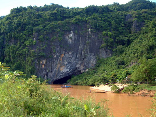
The karst formation process has led to the creation of not only underground rivers but also a variety of cave types including; dry caves, terraced caves, suspended caves, dendritic caves and intersecting caves. With a length of over 44.5 km the Phong Nha cave is the most famous of the system with tour boats able to penetrate inside to a distance of 1,500 m.
A large number of faunal and floral species occur within the property with over 568 vertebrate species recorded comprising 113 mammals, 81 reptiles and amphibians, 302 birds and 72 fish. This impressive level of biodiversity and species richness includes a number of endemic species as well as threatened species including tiger, Asiatic black bear, Asian elephant, giant muntjac, Asian wild dog, gaus and the recently discovered sao la.
Criterion (viii): Phong Nha is part of a larger dissected plateau, which also encompasses the Ke Bang and Hin Namno karsts. The limestone is not continuous and demonstrates complex interbedding with shales and sandstones. This, together with the capping of schists and apparent granites has led to a particularly distinctive topography.
The caves demonstrate discrete episodic sequences of events, leaving behind various levels of fossil passages, formerly buried and now uncovered palaeokarst (karst from previous, perhaps very ancient, periods of solution); evidence of major changes in the routes of underground rivers; changes in the solutional regime; deposition and later re-solution of giant speleothems and unusual features such as sub-aerial stromatolites. The location and form of the caves suggests that they might owe much of their size and morphology to some as yet undetermined implications of the schists and granites which overlay the limestone. On the surface, there is a striking series of landscapes, ranging from deeply dissected ranges and plateaux to an immense polje. There is evidence of at least one period of hydrothermal activity in the evolution of this ancient mature karst system. The plateau is probably one of the finest and most distinctive examples of a complex karst landform in Southeast Asia.
Phong Nha displays an impressive amount of evidence of earth’s history. It is a property of very great importance for increasing our understanding of the geologic, geomorphic and geo-chronological history of the region.
Integrity
Covering an area of 85,754 ha and bounded on the west by the Lao People’s Democratic Republic, all elements necessary to manifest the outstanding geological values of the property of Phong Nha – Ke Bang National Park are contained within the boundaries of the property. The inscribed property is completely surrounded and protected by a buffer zone of approximately 200,000 ha and is designated into three management zones; Strictly protected (64,894 ha), ecological recovery (17,449 ha) and administrative service (3,411 ha).
There are a number of issues that affect the integrity of the property. These include the fact that a part of the major watershed is not contained within the boundaries of the property and that a road crosses the property. While former problems with poaching posed a threat to the values contained within the site these are now considered to be under effective control. However, continued management actions and monitoring is required to ensure poaching does not become an issue in the future.
The property is situated within an area of high population density and as such a number of activities, such as cultivation, tourism, transport and fisheries also impact on the integrity of the property. However, these activities are currently under strict control and management. As a result, the natural landscape, geologic and geomorphic values, and key features such as primitive forest, caves, rivers and streams within the inscribed area are all intact.
Protection and management requirements
Originally designated as a Nature Reserve in 1986, Phong Nha – Ke Bang National Park was established in 2001 under the Decision 189/QD-TTg by the Prime Minister and is managed by a Management Board. The management board is responsible for protection of forest resources and biodiversity and was established in 1994. Cave conservation and the provision of a tourism service are the responsibility of the Cultural and Ecological Tourist Centre under the Management Board. The site management is conducted by more than 470 staff members from many different technical backgrounds. The property is also included in the Special National Heritage List (2009), and the Special Use Forest system (1999). The National Park is effectively protected by a number of national laws and government decisions, which prohibit any action to be under taken inside or outside the boundaries of the National Park or a World Heritage property that may have a significant impact on the heritage values.
A management plan was prepared in 2010 providing for rigorous conservation programmes, and a revised master plan is under preparation. A visitor management plan has also been prepared along with a provincial action plan to control hunting and trade in wildlife, which was implemented from 2005. Additionally, the Management Board has set up ten ranger stations and a mobile patrol unit to prevent poaching within the property. The rugged nature of the country, difficulty of control, and low income of many local families and relative shortage of resources for control purposes means that wildlife poaching and illegal timber gathering are difficult to eliminate and this challenging issue will require further efforts into the future if it is not to continually impact the property.
The Ho Chi Minh highway, constructed outside and to the north of the property is clearly justifiably and appropriately located. It provides important and valuable benefit to the National Park in terms of opening up views of and access to the Ke Bang forest area. The highway also greatly enhances year-round traffic flow from the North and South of the country as a whole, constructed with a high level of environmental responsibility the road linking the highway and route 20, which crosses the property, is small and has little impact on its natural values. Other road construction in the area requires careful planning and construction as impacts from construction processes as well as indirect impacts on the property may threaten the values of the site.
Impacts of increased development pressure and tourism numbers also require further consideration, planning and management. In the long-term, management of the property focuses on ensuring the integrity of the geological and geomorphologic values, as well as the property’s environment; strengthening the legislative provisions; carefully monitoring the socio-economic activities within the national park; designing suitable eco-tours; increasing the usage of technology in heritage management; undertaking research to gain a better understanding of the property’s values; improving the staff capacity and enhancing community awareness and involvement.
Long Description
The Phong Nha Nature Reserve is situated on the edge of the Phong Nha/Ke Bang Karst plateau in central Viet Nam. It is only part of the total plateau, which extends to and adjoins the Hin Namno karst of the Lao PDR. Phong Nha contains many large and spectacular caves. The karst landscape is an extremely complex and ancient one, with high geodiversity and some geomorphic features of considerable significance. It has an Earth crust development history from the Ordovician period (464 million years ago). This has produced three types of topography and geomorphology. One type is the non-karst landforms, which consist of low, round-top mountains with planation surfaces and abrasion-accumulation terraces along the valleys of the Son and Chay rivers and at the margins of the central limestone massif. The other major type is karst landforms, which are characterized by old tropical karst mainly from the Mezozoic era, but two-thirds of the site consists of karst from the Cenozoic. Extensive transitional landforms comprise an extremely complex intercalation of limestone massifs and terrigenous terrain with a diversity of rock types. The limestone occupies an area of about 200,000 ha, with a similar adjacent area in the Lao People’s Democratic Republic and its highest point is 1,290 m above sea level.
The karst formation process has resulted in many features such as underground rivers, dry caves, terraced caves, suspended caves, dendritic caves and intersecting caves. The active river caves are divided into the nine caves of the Phong Nha system discharging to the Son River, and the eight caves of the Vom system discharging to the Chay River. The Phong Nha Cave is the most famous in the entire system, with a currently surveyed length of 44.5 km. Its entrance is the last part of an underground river that connects with the Son River and tour boats can penetrate inside to a distance of 1,500 m. Other extensive caves include the Vom cave at 15 km in length and the Hang Khe Rhy cave with a length of 18,902 m.
Some 92% of the park is covered by tropical forest, 92.2% of which is primary forest. By far the largest vegetation type is tropical dense moist evergreen forest on limestone. Although this was severely damaged by fire during the war, it is recovering rapidly and is now in a healthy state. It has a high level of faunal diversity and there are many vascular plants.
A total of 568 vertebrate species have been recorded in the site, comprising 113 mammals, 81 reptiles and amphibians, 302 birds and 72 fish. The fauna is typical of the limestone karst forests of the Annamite mountains. The high mammal species richness includes threatened species such as tiger, Asiatic black bear, Asian elephant, giant muntjac, Asian wild dog, gaus, and the newly discovered sao la. The site is particularly rich in primates, with 10 species and subspecies forming 45% of the total number of species in Viet Nam.
The Phong Nha-Ke Bang karst has evolved since the Palaeozoic era and so is the oldest major karst area in Asia. It has been subject to massive tectonic changes. The karst landscape of the park is extremely complex with high geodiversity and many geomorphic features of considerable significance.
The limestones of Phong Nha are interbedded with a number of other rocks. There is also strong evidence that sulphurous solution and hydrothermal action have played an important role in shaping the broad-scale landscape and the caves. The incorporation of the Ke Bang forest into the park has added another very important dimension.
This sector has many ‘fossil’ caves at a high level, which occur when the groundwater and rivers move to a lower level. Only a very few have been visited to date. It is one of the most important eco-regions of the Indo-Pacific. A large number of faunal and floral species occurs in the park, including some endemic to the site.

